Burke County, North Carolina
From ENC Phillips Group Wiki
| Burke County | |

| |
| Founded 1777 | |
| Website http://www.co.burke.nc.us | |
Burke County is a county located in the U.S. state of North Carolina. As of 2000, the population was 89,148. Its county seat is MorgantonTemplate:GR.
The first European settlement in the interior of North Carolina and what would become the United States was made by Spanish in 1567, when they built Fort San Juan at the large Native American settlement of Joara near present-day Morganton. They renamed the settlement Cuenca.[1] However the following year the Indians killed the Spanish and burned the fort. It was two centuries before Europeans tried to settle there again.
Contents
History
Native Americans of the Mississippian culture inhabited the county long before Europeans arrived in the New World. The largest Mound Builder settlement was at Joara, a Template:Convert site and regional chiefdom near present-day Morganton. It was the center of the largest Native American settlement in North Carolina, dating from about 1000 A.D. and expanding into the next centuries.[1]
In 1567 a Spanish expedition arrived and built Fort San Juan, claiming the area for the colony of Spanish Florida. They had been sent by the governor at Santa Elena, Parris Island in South Carolina. Captain Juan Pardo, leader of the expedition, left about 30 soldiers at the fort while continuing his exploration. In the spring of 1568 the Indians attacked the fort, killing the soldiers and burning the fort. Introduction of European diseases and takeover by larger tribes led to Native American abandonment of the area. It would be centuries before the next Europeans - English, Scots-Irish and Germans - attempted to settle here again.[1]
In 1777, Burke county was formed from Rowan County. It was named for Thomas Burke, a delegate to the Continental Congress from 1777 to 1781 and Governor of North Carolina from 1781 to 1782. The western Piedmont was settled by many Scots-Irish and German immigrants in the mid- to late 18th century. They were generally yeoman farmers and fiercely independent. Very few families were slaveholders.
The county was divided over the years to form other jurisdictions. In 1791 parts of Burke County and Rutherford County were combined to form Buncombe County. In 1833 parts of Burke County and Buncombe County were combined to form Yancey County. In 1841 parts of Burke County and Wilkes County were combined to form Caldwell County. In 1842 additional parts of Burke County and Rutherford County were combined to form McDowell County. Finally, in 1861 parts of Burke County, Caldwell County, McDowell County, Watauga County, and Yancey County were combined to form Mitchell County.
Burke County was the site of the final strategy meeting that led the 1,000 Appalachian frontiersmen battling in the British commander Ferguson at Kings Mountain in the American Revolution, rather than waiting for him to come to them. The militiamen crossed over the mountains and thus were called the "Over Mountain Men".Template:Citation needed
Townships
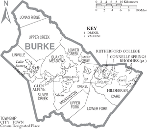
The county is divided into thirteen townships: Drexel, Icard, Jonas Ridge, Linville, Lovelady, Lower Creek, Lower Fork, Morganton, Quaker Meadows, Silver Creek, Smoky Creek, Upper Creek, Upper Fork and Valdese.
Adjacent counties
- Avery County, North Carolina - northwest
- Caldwell County, North Carolina - north
- Catawba County, North Carolina - east
- Cleveland County, North Carolina - south-southeast
- McDowell County, North Carolina - west
- Rutherford County, North Carolina - south-southwest

|
Avery County | Caldwell County | 
| |
| McDowell County | Catawba County | |||
| Rutherford County | Cleveland County |
Cities and towns
Partially in other counties
Census designated places
References
<reference/>
External links
| This page uses content from the English language Wikipedia adapted for use as a quick research reference on this wiki. The original content was here: Burke County, North Carolina. The list of authors can be seen in the page history. As with the ENC Phillips Group Wiki, the content of Wikipedia is available under the Creative Commons License. |
- ↑ 1.0 1.1 1.2 David Moore, Robin Beck, and Christopher Rodning, "In Search of Fort San Juan: Sixteenth Century Spanish and Native Interaction in the North Carolina Piedmont", Warren Wilson College Archaeology Home Page, 2004, accessed 26 Jun 2008

