Alamance County, North Carolina
From ENC Phillips Group Wiki
| Alamance County | |

| |
| Founded 1849 | |
| Website http://www.alamance-nc.com | |
Alamance County is a county formed in 1849 from Orange County to the east. Alamance County has been the site of significant historical events, textiles, manufacturing, and agriculture in North Carolina. Its county seat is Graham.
Contents
History
Before being formed as a county, the region had at least one known small Southeastern tribe of Native American in the 1700s - the Sissipahaw who lived in the area bound by modern Saxapahaw, the area known as the Hawfields, and Haw River in the county [1][2] European settlers entered the region in the late 1600s chiefly following Native American trading paths, and set up their farms what they called the "Haw Old Fields", fertile ground previously tilled by the Sissipahaw. The paths later became the basis of the railroad and interstate highway routes.[3]
Alamance County was named after Great Alamance Creek, site of the Battle of Alamance (May 16, 1771). This pre-Revelutionary War battle in which militia under the command of Governor William Tryon crushed the Regulator movement. The Great Alamance Creek, and in turn the Little Alamance Creek, according to legend, were named after a local Native American word to describe the blue mud that was found at the bottom of the creeks. Other legends say that the name came from another local Native American word meaning "noisy river" or for the Alamanni region of Rhineland, Germany, where many of the early settlers would have come from.
During the American Revolution, several small battles and skirmishes occurred in the area that would one day become Alamance County, several of them during the lead-up to the Battle of Guilford Courthouse, including Pyle's Massacre, the Battle of Lindley's Mill[4] and the Battle of Clapp's Mill.
In the 1780s, the Occaneechi Native Americans returned to North Carolina from Virginia, this time settling in what is now Alamance County rather than their first location near Hillsborough.[5] In 2002, the modern Occaneechi tribe bought 25 acres of their ancestral land in Alamance County and began a Homeland Preservation Project which includes a village reconstructed as it would have been in 1701 and a 1930s farming village.[5]
During the early 19th century, the textile industry grew heavily in the area, and as such, the need for better transportation grew. By the 1840s several mills were set up along the Haw River and near Great Alamance Creek and other major tributaries of the Haw. Between 1832 and 1880, there were at least 14 major mills powered by these rivers and streams. Mills were built by the Trollinger, Holt, Newlin, Swepson, and Rosenthal families, among others. One of the mills, built in 1832 by Ben Trollinger, is still in operation. It is owned by Copland Industries and sits in the unincorporated community of Carolina and is the oldest continuously-operating mill in the state of North Carolina.[6]
One of the notable textiles produced in the area were the "Alamance Plaids" or "Glencoe Plaids" used in everything from clothing to tablecloths.[6] The Alamance Plaids manufactured by textile pioneer Edwin M. Holt were the first colored cotton goods produced on power looms in the South, and paved the way for the region's textile boom. (Holt's home is now the Alamance County Historical Society.) But by the late 20th century, most of the plants and mills had now gone out of business, including the mills operated by Burlington Industries, a company that was based in Burlington.
By the 1840s, the textile industry was booming, and the railroad was being built through the area as a convenient link between Raleigh and Greensboro. The county was formed January 29, 1849 [7] from Orange County.
Adjacent counties

|
Rockingham County | Caswell County | 
| |
| Guilford County | Orange County | |||
| Randolph County | Chatham County |
Municipalities and communities
Incorporated cities and towns
Alamance County's Incorporated Cities and Towns are home to over 93,850 people.[8]
|
|
|
Townships
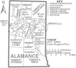
The county is divided into thirteen townships, which are both numbered, named, and contain the following municipalities:
|
|
Unincorporated communities
Over 54,000 people do not live in an incorporated community in Alamance County.
|
|
|
Ghost Towns
According to a 1975 study of the history of post offices in North Carolina history by Treasure Index, Alamance County has 27 ghost towns that existed in the 18th and 19th Centuries that no longer exist. Additionally, five other post offices no longer exist. These towns and their post offices were either abandoned as organized settlements, or were absorbed into the larger communities that now make up Alamance County.[9]
|
|
|
References
- ↑ John R. Swanton, "North Carolina Indian Tribes", Indian Tribes of North America, 1953, at Accss Genealogy, accessed 25 Mar 2009
- ↑ "Sissipahaw Indian Tribe History", John R. Swanton, Indian Tribes of North America, 1953, at Access Genealogy, accessed 25 Mar 2009
- ↑ "The Trading Path in Alamance County, a Beginning", Alamance County Historical Association, Trading Path Association: Preserving our Common Past
- ↑ Battle of Lindley's Mill
- ↑ 5.0 5.1 "Occaneechi Band of the Saponi Nation". Southern Neighbor. November 2009.
- ↑ 6.0 6.1 http://www.textilehistory.org/AlamanceCountyNC.html
- ↑ Alamance County North Carolina Genealogy
- ↑ Populations given are from the 2008 Census Estimate (Microsoft Excel file)
- ↑ Burlington Times-News, December 11, 1975
| This page uses content from the English language Wikipedia adapted for use as a quick research reference on this wiki. The original content was here: Alamance County, North Carolina. The list of authors can be seen in the page history. As with the ENC Phillips Group Wiki, the content of Wikipedia is available under the Creative Commons License. |

