Chiaves-map-xuala-1584.jpg
From ENC Phillips Group Wiki
No higher resolution available.
Chiaves-map-xuala-1584.jpg (442 × 257 pixels, file size: 35 KB, MIME type: image/jpeg)
Summary
| Description |
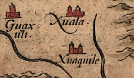
English: Detail of the Native American village of Joara (spelled "Xuala" on the map) and two neighboring villages in what is now North Carolina, in the southeastern United States, on Chiaves' 1584 map of La Florida. The map was drawn by Spanish royal cartographer Geronimo Chiaves, and was probably based on accounts by members of the Hernando De Soto expedition (1539-1543). The map was originally published in Abraham Ortelius' Theatrum Orbis Terrarum in 1584. |
| Date | |
| Source | https://www.loc.gov/exhibits/earlyamericas/online/aftermath/aftermath2.html |
| Author | Geronimo Chiaves, Abraham Ortelius |
Licensing
|
This work is in the public domain in its country of origin and other countries and areas where the copyright term is the author's life plus 100 years or fewer. | |
| This file has been identified as being free of known restrictions under copyright law, including all related and neighboring rights. | |
File history
Click on a date/time to view the file as it appeared at that time.
| Date/Time | Thumbnail | Dimensions | User | Comment | |
|---|---|---|---|---|---|
| current | 19:38, 3 July 2008 | | 442 × 257 (35 KB) | BrineStans | {{Information |Description={{en|1=Detail of the Native American village of Joara (spelled "Xuala" on the map) and two neighboring villages in what is now North Carolina, in the southeastern United States, [http://commons.wikimedia.org/wiki/Image:Chiaves-l |
File usage
The following page links to this file: